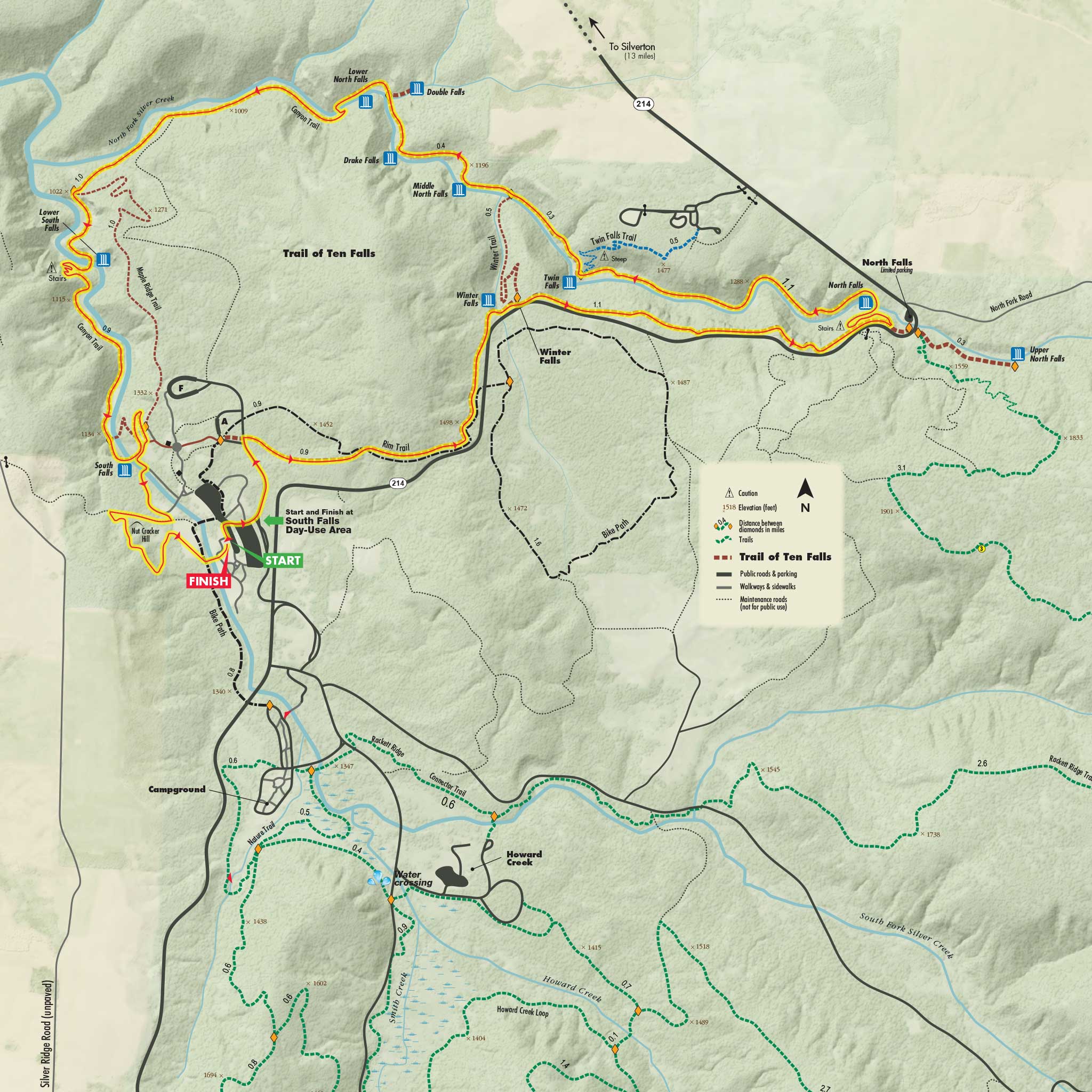
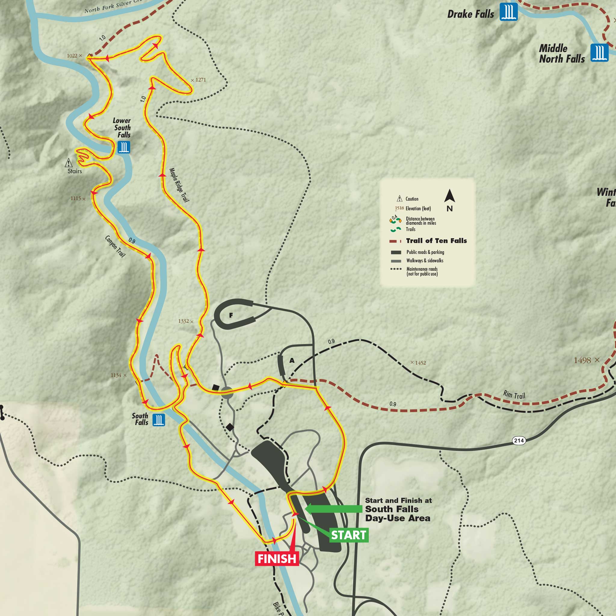
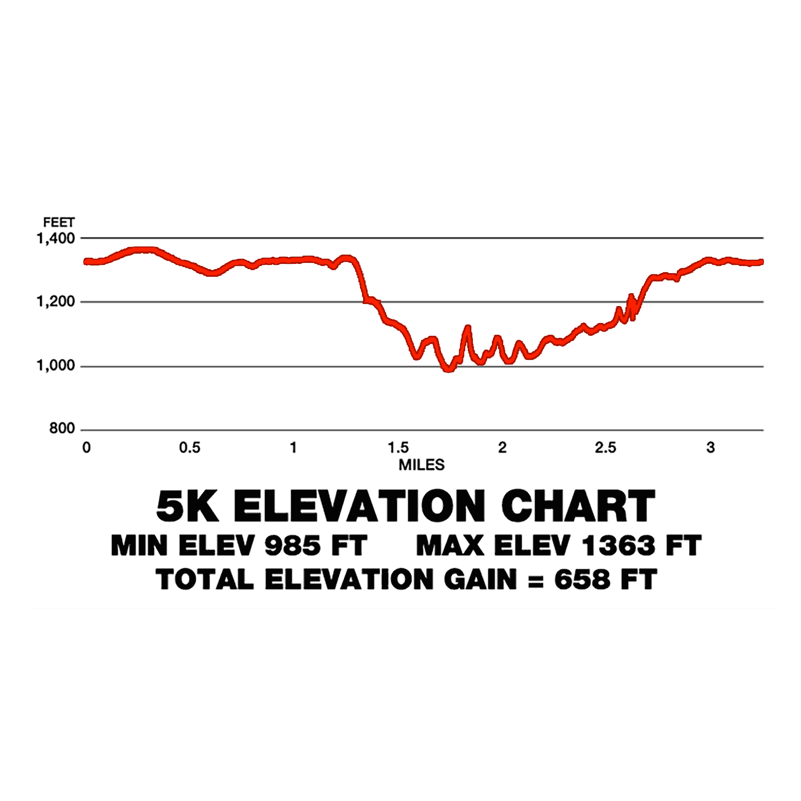
5K Course

A very scenic 5k trail run that starts and finishes at south falls day use area. The run begins by heading up a short paved road then turns down to a paved path that takes runners to the Maple Ridge Trail. Once here, the course remains flat for a short while before it takes a steep plunge down to the canyon trail. The course turns left on the canyon trail and begins it’s journey under 2 spectacular waterfalls and climbs back up to the top of South Falls. At this point the course turns right and crosses the foot bridge just above South Falls and follows a paved path and grass field right back to the finish. Sorry, no pets or strollers allowed on courses. No aid stations. Elevation gain of 658 ft.

GPS (Garmin)

7 Miler Course

A scenic 7 mile trail run that starts and finishes at South Falls day use area. The run begins by heading up a short paved road to the rim trail, and once here enjoys amazing and scenic trails with some elevation gain and loss. At the end of rim trail the course takes a left down towards North Falls. The next 4+ miles are the most scenic as it follows the famous “Trail of Ten Falls” that passes near and under several spectacular waterfalls all the way back to the top of South Falls. At this point the course turns right and crosses the bridge just above South Falls and makes it’s way back to a final climb up “Nut Cracker Hill” and back down to the finish. Sorry, no aid stations. Strollers and pets not allowed on courses. Elevation gain of 980 ft.

GPS (Garmin)

Half Marathon Course

Featured in Runners World magazine and race center magazines and also voted “best oregon trail half marathon” this course is perhaps the most scenic and beautiful on the west coast! The race begins at the popular south falls day use area of Silver Falls State Park that includes a covered pavilion w/fireplace, large tent, several restrooms and ample paved parking. The first 1.1 mile is on a scenic paved road to allow runners to spread out before hitting the trails. Course preview here. Amazing views, huge fir trees, several bridge crossings and lung busting hills make up this picturesque 13.1 mile course that passes under and near several spectacular waterfalls! Popular trails include canyon trail, maple ridge trail and rim trail mixed with portions of paved paths and gravel road. Course will be well marked, have 3 well stocked aid stations and signs at each mile. Sorry, pets are not allowed on courses. Walker friendly course!

GPS (Garmin)Aid Stations

Marathon Course

The Silver Falls Marathon is challenging, but quite possibly the most amazing and beautiful course on the west coast! Features significant elevation gain with mud, rocks, a creek crossing and lots of hills! Course begins in the south falls day use area and features a total of 6 aid stations. The marathon follows the same scenic course as the half and at the 2 nd aid station (mile 6) splits off and begins it’s own 13+ mile journey in the back country trails of Silver Falls State Park. Huge fir trees, several bridge crossings, lung busting hills, a creek water crossing (mile 9), amazing single track trails and wildlife greet runners in this remote area! After joining back with the half course at aid station #5 (mile 19.1) the marathon now enjoys the stunning and scenic canyon trail with several spectacular waterfalls along the way back to the finish at south falls day use area. Course will be well marked and will have mile markers at all aid stations. Sorry, no pets or walkers allowed on courses.

GPS (Garmin)VideoCut Off TimesAid Stations

50K Course

Very scenic and challenging 50k Ultra in the mid Willamette Valley nearby the capitol city of Salem! This course may rank as one of the most scenic 50k’s on the west coast! Features significant elevation gain with mud, rocks, a creek crossing (mile 12) and lots of hills! Course begins at the south falls day use area and features a total of 7 aid stations. The 50k follows the same beautiful courses as the half and full and like the full marathon (at the north falls aid station mile 6) splits off from the half course and begins it’s own journey in the back country trails of silver falls state park. Huge fir trees, several bridge crossings, lung busting hills, amazing single track trails and wildlife greet runners in this remote area! After joining back with the half course at aid station #6 (n. falls mile 24.4) the 50 k now enjoys the beautiful and scenic canyon trail running alongside and under several spectacular waterfalls along the way back to the finish at south falls day use area. This amazing course covers almost every major landmark on the 9000 acre Silver Falls State Park (Oregon’s largest state park). Course are well marked with arrows, signs, cones and will have mile markers at all aid stations. Sorry, no pets or walkers allowed on courses.

GPS (Garmin)VideoCut Off TimesAid Stations